A High-Tech Network of the Middle Ages
Centuries ago, during the height of the Byzantine Empire’s power, the state operated a remarkably efficient communication system that spanned vast territories. This system, based on strategically placed beacon towers (called Byzantine beacon communication system), enabled rapid message transmission across great distances; long before the age of modern technology.
The Beacon Line from Cilicia to Constantinople
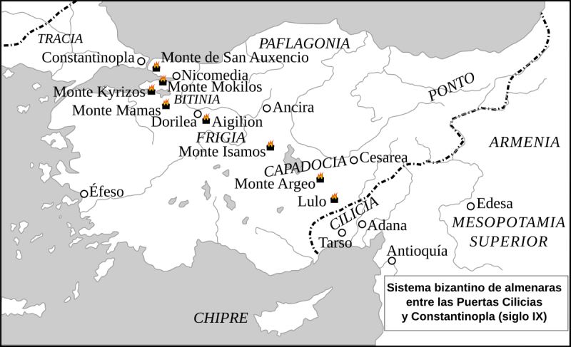
The map referenced shows a beacon line stretching from Cilicia (modern-day southern Turkey) all the way to Constantinople (modern-day Istanbul), designed by the mathematician Leo in the 9th century. This was not the only beacon line: a second line extended from the Lycian region through western Anatolia to reach Constantinople, while another spanned the Balkans, beginning near the Danube River and also ending in the imperial capital.
How the System Worked
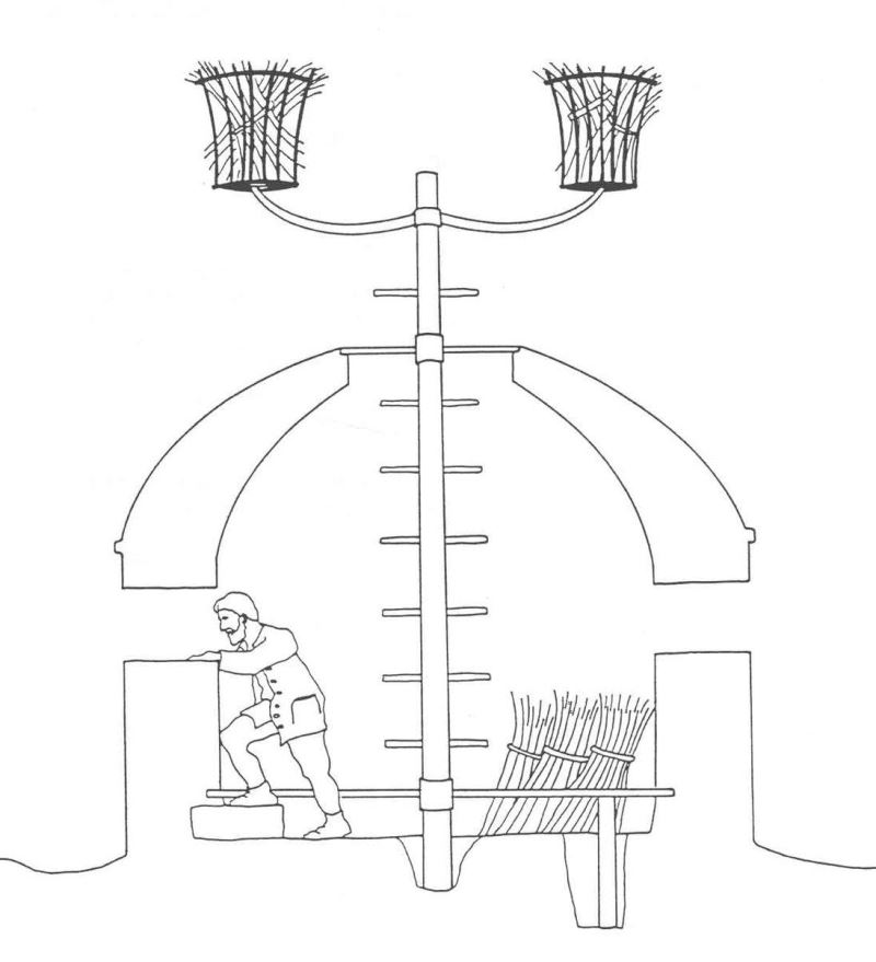
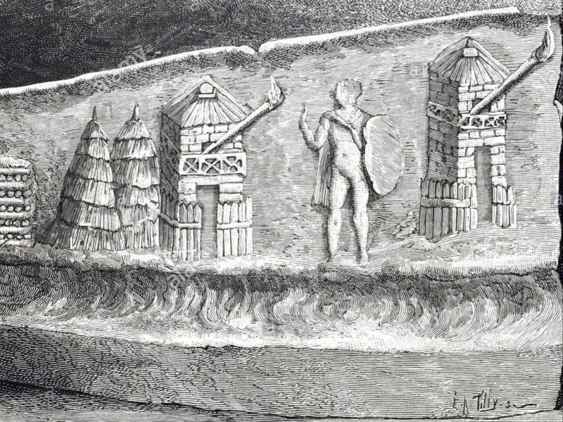
The system relied on bonfires lit on mountaintop towers, each positioned so that its signal could be seen from the next. When the garrison of one tower saw a fire from its neighbor, they would light their own fire in response. In this way, a single binary signal (on/off) could be transmitted across the entire line within roughly an hour.
To convey more complex messages, the system also utilized synchronized clocks at each tower. The time at which a beacon was lit carried specific meanings. For example, if the fire was lit early in the morning, it could signal that a nearby city was under attack. Fires lit at different hours could indicate different threat locations or levels of severity.
While this time-based messaging required waiting for the appropriate hour and thus delayed communication slightly, it was still far faster than dispatching a mounted messenger. A horseman traveling from the Cilician Gates to Constantinople could take days; the beacon system delivered signals in a fraction of that time.
Strategic Use in Warfare
The Byzantine Empire made extensive use of this system, especially during the 9th century Abbasid–Byzantine wars. It was later refurbished during the 12th century by Emperor Manuel Komnenos and employed against Turkish incursions.
The Main Beacon Line
The southernmost point of the Anatolian beacon network was the Loulon Fortress, located just north of the Cilician Gates. From there, the beacon line continued through the following locations:
- Mount Argaios (near modern-day Hasan Dağı and Keçikalesi)
- Mount Isamos
- Aigilon Fortress (near modern-day Eskişehir)
- Mamas Tower (Uludağ, near Bursa)
- Mount Kyrizos (between Lake İznik and the Gulf of Gemlik, in the Katırlı Mountains)
- Mount Mokilos (Samanlı Mountains)
- Mount Saint Auxentius (modern Kayışdağı)
The final signal point was the lighthouse of the Great Palace (Bukoleon Palace) on the Marmara coast in Constantinople.
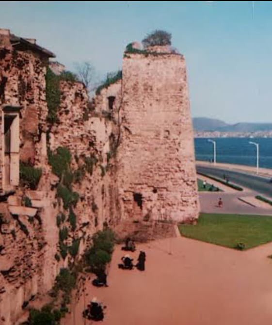
It is estimated that the Lighthouse Tower adjacent to the Bukoleon Palace in Cankurtaran was the Istanbul component of this communication network of the Byzantine-period lighthouse towers.
Branch Beacon Lines
In addition to the main line, there were secondary beacon routes that connected to this central network. In Central Anatolia, the towers were spaced roughly 100 km apart. In Bithynia (in the northeast), the rugged terrain reduced the distance between towers to around 50 km.
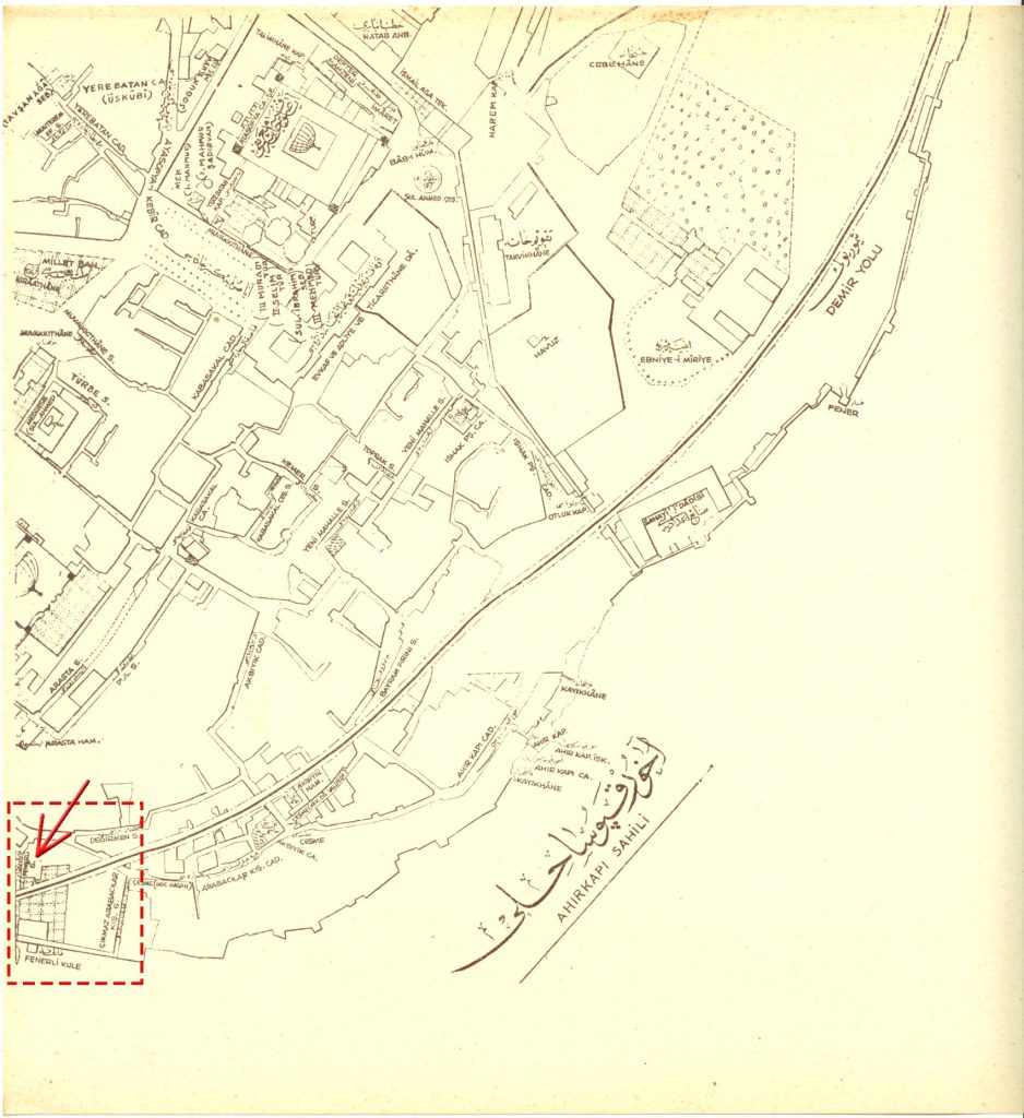
In the 19th-century map of Istanbul’s historic peninsula (Suriçi) published by Ekrem Hakkı Ayverdi, the lighthouse adjacent to the Bukoleon Palace is marked as the “Tower with the Lantern” (Fenerli Kule). The street behind it was also named Fenerli Street. Today, due to land reclamation, the coastline has changed, and both the streets and their names have been altered.
A Broader Historical Context
The Byzantines were not the first or only civilization to use beacon towers for communication. The Roman Empire had employed similar systems, particularly to monitor northern invasions by barbarian tribes.
In the Han Dynasty (2nd century BCE), the Great Wall of China was also equipped with beacon and watchtowers used to send warnings across long distances; another example of early optical telecommunication.
Even earlier in Anatolia, the Urartians (9th–6th centuries BCE) are believed to have used beacon towers, though very few remains of their system have been discovered.
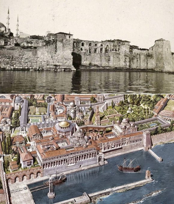
The Fenerli Kule (the rightmost structure), located in Cankurtaran, is believed to have been the Istanbul end of the optical signal system that began at the Cilician Gates.
The photo shows the 19th-century appearance of the Bukoleon Palace, before the coastal land reclamation. The drawing is a reconstruction attempt by Byzantium 1200.
From Beacons to Shrines
Interestingly, many Byzantine beacon towers have survived to this day, and some of the smaller, auxiliary Byzantine beacon communication system towers are located near shrines known as “Işık Dede“ or “Işık Baba“ (“Light Grandfather”). These sites seem to have been transformed over the centuries from military watchpoints into spiritual places, sanctified by local traditions and veneration.