
As one of the fastest developing cities of Turkey, Adıyaman includes a part of Atatürk Dam within its border. Having counties in both Mediterranean and Eastern Anatolia Regions, Adıyaman is a province where four seasons coexist. At the north side of the city is Malatya; at the west side is Kahramanmaraş; at the southwest side is Gaziantep; at the southeast side Şanlıurfa, and finally, at the east side Diyarbakır. It has 406 villages and 19 counties, including the central county.
The north side of Adıyaman is surrounded by Malatya Mountains which is an extension of Toros Mountains. Gerger and Çelikhan ve Tut counties of the city feature mostly mountainous areas. The main mountains in our city are Dibek, Akdağ, Ulubaba, Gördük, Bozdağ, and Nemrut ve Karadağ Mountains. Towards the southern parts of the province, lands regarded as lowland stand out. Samsat, Keysun, Pınarbaşı, and Kahta lowlands take their place as the main lowlands of the city. Fırat River is the most important stream of Adıyaman. Other rivers in the area are Ziyaret, Sofraz, Kalburcu, Eğri, Akdere, Şepker, and Çakal rivers. İnekli, Azaplı, and Gölbaşı are natural lakes while Atatürk Dam is an artificial lake in our province.
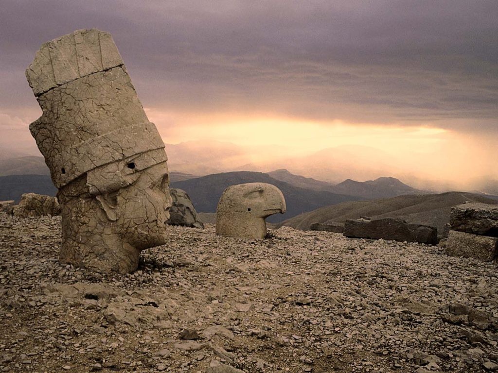
Mt Nemrut
The province acts as a bridge between Southeastern Anatolia and the eastern Anatolia regions. It partially carries the characteristics of Mediterranean Region, which is why its vegetation includes all types of climates.
As one of the cities which witnessed history, Adıyaman province has a quite rich history. There are many historical places and natural beauties to visit, including Adıyaman, Adıyaman castles, Adıyaman mosques, and Adıyaman rock graves; all of these places carry the remnants of an ancient history to the present day.
Places to Visit
- Nemrut Mountain Ruin Site: This place is called as the 8th wonder of the world and stands on a UNESCO Culture Heritage List. It is located on Toros Mountains.
- Arsameia Holy Area: It is located in Kahta County and belongs to Hellenistic Period from the 3rd century B.C.
- Pirin Ruin Site: It is 5 kilometers away from the city and one of the five main cities of Commagene reign.
- Derik Holy Area: There are sacred boundary walls, a temple, and two Herons in this area.
There are many historical places and natural beauties to visit.
- Palanlı Cave: It was used through Paleolithic Period during which Stone Age people lived. It is understood from cave pictures that people of this era did hunting and collecting.
- Turuş Rock Graves,
- Rock Monuments,
- Adıyaman Castle,
- Yeni Castle,
- Gerger Castle,
- Ulu Mosque, Çarşı Mosque, Eskisaray Mosque, Kap Mosque, Yeni Pınar Mosque,
- Nemrut National Park,
- Karakuş Tumulus
How to Get There
The highway is the preferred path to travel to the Adıyaman province. It is possible to get to the city from anywhere in our country. Airport is the transportation network which came into service in 1998; thanks to the airport, transportation to most of Turkey’s provinces is available. You might also consider traveling via railway.